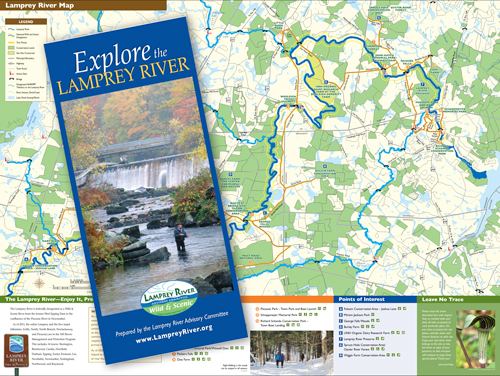
Detail of the Explore the Lamprey River Map
  • Members
  •   |   Contact Us
  •   |   FAQ
  •   |   Subscribe
  • Documents & Resources
  • About LRAC
    • Important Documents
    • Our History
    • Our Responsibilities
    • Our Research
    • Funding & Key Investments
    • Meetings
    • Meeting Minutes
    • Annual Reports
    • LRAC: Twenty Years of Progress
    • Wild and Scenic Subcommittee
    • NH Rivers Program Members
    • Work Groups
    • River Protection Programs
    • LRAC Community Grants Program
    • LRAC Research Grant Program
    • Sitemap
  • News
    • Newsletters
    • Legislative Tracking
  • About the River
    • Watershed Terms
    • LRAC Studies
    • History
    • Water Quality and Quantity
    • Land Protection
    • Project Review
    • Instream Flow
    • Wildlife & Ecology
    • Lamprey History
  • Recreation
    • Parks
    • Explore the Lamprey River Guide
    • Maps
    • Town Trails
    • Public Swimming River or Lake
    • Public Canoe Access
    • Canoeing the Lamprey
    • Lamprey River Big Tree Tour
    • Walking Trail Feasability Study
  • Fun for Kids!
    • Chick & Dee-Dee
    • Animals & Plants on the Lamprey
  • Education & Outreach
    • Elementary Curriculum
    • Middle and High School Curriculum
    • Field Trips
    • Presentations for adults and small groups
    • Materials
  • Videos
    • River Story
    • (NH Naturalist) David Carroll videos
    • Reflections on a River
    • Wiswall's Mill
    • Connecting Lives
    • Mary Blair Park
    • Spring into Vernal Pools
    • Streamwalk
    • River Connections
    • 5000 Miles of Wild
    • Video Shorts

Lamprey River Advisory Committee: helping communities protect and enjoy the Lamprey River through resource protection, research and outreach. 

  1. Home
  2. Recreation
  3. Maps

Maps

Explore the Lamprey River Tourguide

Explore the Lamprey River contains a  map and guide for recreational highlights along the river in Epping, Lee, Durham, and Newmarket.  Highlights include sites for canoeing, visiting historic sights, exploring different habitats, and just spending time at scenic areas. The guide includes directions to the various locations and suggested activities. Full size, professionaly printed maps are available for free at many local libraries or by requesting one directly from the committee.

  • Explore the Lamprey River Guide

  • Explore the Lamprey River Guide Map

  • Public Paddling Access Map

Other maps:

  • Explore the Lamprey map 2022
  • Mulligan Forest Trail, Nottingham, NH
  • Pawtuckaway State Park, Nottingham, NH
  • Dearborn Property Trail Map
  • Lillian M Cassier Memorial Forest Trail Map
  • Public Paddling Access along the Lamprey River for Screen
  • Deerfield Community Trail Overview
  • Great Brook Trail Map
  • Great Brook Trail Inventory and Needs
  • Dowst-Cate Trail Map
  • Dowst-Cate Trail Inventory and Needs
  • Lindsay-Flanders Trail Map
  • Freese's Pond Trail Map
  • Freese's Pond Inventory and Needs
  • Arthur Chase Trail Map
  • Arthur Chase Trail Inventory and Needs
  • Deerfield Potential Future Trails
  • Deerfield Summary of Conserved Land
  • Inventory Photos
  • Explore the Lamprey River Guide
  • Public Paddling Access along the Lamprey River, print-ready
  • Lamprey River Walking Path Feasability Study
  • Documents & Resources
  • About LRAC
    • Important Documents
    • Our History
    • Our Responsibilities
    • Our Research
    • Funding & Key Investments
    • Meetings
    • Meeting Minutes
    • Annual Reports
    • LRAC: Twenty Years of Progress
    • Wild and Scenic Subcommittee
    • NH Rivers Program Members
    • Work Groups
    • River Protection Programs
    • LRAC Community Grants Program
    • LRAC Research Grant Program
    • Sitemap
  • News
    • Newsletters
    • Legislative Tracking
  • About the River
    • Watershed Terms
    • LRAC Studies
    • History
    • Water Quality and Quantity
    • Land Protection
    • Project Review
    • Instream Flow
    • Wildlife & Ecology
    • Lamprey History
  • Recreation
    • Parks
    • Explore the Lamprey River Guide
    • Maps
    • Town Trails
    • Public Swimming River or Lake
    • Public Canoe Access
    • Canoeing the Lamprey
    • Lamprey River Big Tree Tour
    • Walking Trail Feasability Study
  • Fun for Kids!
    • Chick & Dee-Dee
    • Animals & Plants on the Lamprey
  • Education & Outreach
    • Elementary Curriculum
    • Middle and High School Curriculum
    • Field Trips
    • Presentations for adults and small groups
    • Materials
  • Videos
    • River Story
    • (NH Naturalist) David Carroll videos
    • Reflections on a River
    • Wiswall's Mill
    • Connecting Lives
    • Mary Blair Park
    • Spring into Vernal Pools
    • Streamwalk
    • River Connections
    • 5000 Miles of Wild
    • Video Shorts
©2025 Lamprey River Advisory Committee. Contact Us Via Email - Site Design By Wetherbee Creative