
Watershed Terms
The Water Cycle (Hydrologic Cycle)
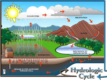
As seen in the diagram above, water is continually recycled. The water we use today is the same water that the dinosaurs used. It falls from the sky, travels across and through the land, evaporates, condenses, and falls again.
Watershed
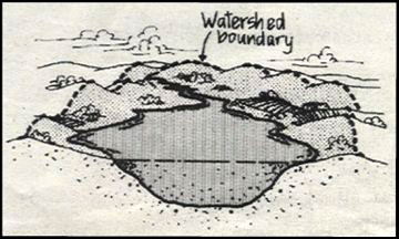
A watershed is an area of land where all water from the area drains into a given stream, river, lake or other water body. Our landscape is made up of many inter-connected watersheds. For example, the Lamprey River watershed is only one of several watersheds that drain into Great Bay.
Today, we are beginning to understand that in order to protect a river, we must protect the whole watershed. We have to include aquifers, wetlands, groundwater, marshes, streams and estuaries, plus forests, fields and other upland areas, because all parts of the watershed depend on all the other parts.
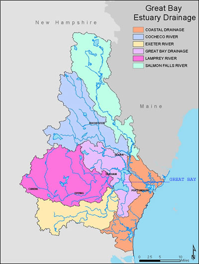
The Lamprey River begins in the Saddleback Mountains in Northwood, New Hampshire and travels 49 miles to Great Bay. The elevation of the Lamprey drops 600 feet along its journey to the sea. All of the ponds, brooks, streams, lakes and rivers within this drainage area are part of the watershed.
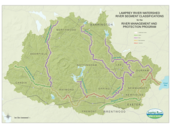
The Lamprey's main tributaries are the North Branch, Pawtuckaway, North, Little, and Piscassic rivers.
The land at the headwaters of the Lamprey River is largely undeveloped and forested. Pawtuckaway State Park and Pawtuckaway Lake are dominant features in the upper watershed. Great Bay is the dominant feature at the river's mouth.
Fourteen towns comprise the Lamprey River watershed: Barrington, Brentwood, Candia, Deerfield, Durham, Epping, Exeter, Fremont, Lee, Newfields, Newmarket, Northwood, Nottingham, and Raymond.
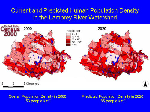
As seen in the chart above, the population in the watershed is growing. More people means more stress on the river and the surrounding watershed. As an example of this increased stress, between 1990 and 2000, the amount of paved surface in the watershed increased by 56%. Fortunately, as of 2010, the watershed was still 68% forested.
River Corridor
A river corridor is the land along the shores of a river. This shoreland is called the "riparian zone." The riparian zone both influences and is influenced by the river. For example, plant species in the riparian zone adapt to the fluctuating water levels. On the other hand, vegetation along the shore impacts the river by providing shade, thus regulating water temperatures. The river corridor is only part of the watershed, but it is usually the part that most people know, because it is used for swimming, canoeing, fishing, hiking and other activities.
The Lamprey River corridor is still relatively undisturbed. Natural habitat conditions for a wide variety of upland and river species are intact. Residential development is the primary form of development along the river; however, some stretches of the river pass through commercial areas, such as downtown Raymond and Epping. Here, shoreline vegetation is reduced, thus minimizing erosion prevention and wildlife habitat.
Several key management challenges affect the health and integrity of the river corridor:
- increased development
- invasive species (unwanted plants and animals that are not native)
- restoration of fish populations
- free fish passage (through fish ladders or through lack of dams)
- the loss of connected tracts of land for safe animal passage
- large water withdrawals
- stormwater run-off that pollutes the river with sediment, high amounts of nutrients/fertilizers, and oily or toxic residues from vehicles
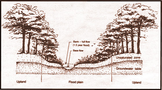
Floodplain
Floodplains are areas of land adjacent to waterways and water bodies that are susceptible to flooding during periods of high precipitation. Flooding occurs when soils become saturated with water and surface runoff increases, because soils cannot absorb any more excess water. The Lamprey River is characterized by seasonal cycles of drought and flooding. Regular flooding renews and maintains the river's extensive floodplains. It also creates habitats in backwater areas for numerous wildlife species. Therefore, flooding is an important part of the dynamic, ever-changing life of the Lamprey River.
Aquifer
An aquifer is a large, underground area that can store a large amount of water. A common type of aquifer is the stratified drift aquifer. The water in an aquifer is called groundwater and many towns use it as their primary source for residential and town water supplies. Protecting all aquifers, even small aquifers with limited groundwater supply, will help to preserve the water quality of the entire watershed and the Lamprey River. Some water falls directly into the river, but most water in the river actually comes from groundwater.
Stratified drift aquifers are scattered across the entire watershed. The Town of Raymond has greater aquifer resources than any other town in the watershed. In Raymond, aquifers underlie the town's entire stretch of the Lamprey River, and the town takes its drinking water from one of these aquifers. An important aquifer in Deerfield underlies the fairgrounds area and extends across town borders into Raymond. A large aquifer in Candia underlies the town dump. Dumps have often been constructed over aquifers, because the sand and gravel composition of the aquifers is easily excavated to bury trash. Building dumps over aquifers can be a threat, however, if metals and other harmful substances leach into the groundwater.
Wetland
A wetland is a land area that is characterized by soil that is often saturated and by the presence of plant species that have adapted to these wet conditions. Wetlands have high levels of nutrients from decaying vegetation and runoff, and therefore usually have lush vegetation. Wetlands adjacent to rivers can be very rich, because they receive additional nutrients from floodwater deposits. The lush vegetation of a wetland provides food and cover for foraging animals and also for predators, who feed on the foragers. Wetlands are an extremely important part of the watershed, and perform these critical functions:
- flood control
- natural stream flow regulation
- erosion and sedimentation control
- water purification
- habitat for plant and animal species
Wetlands are found throughout the Lamprey River watershed, but the majority are located in the upper reaches of the river. The Lamprey River has several different types of wetlands: river channel and riverbanks, marshy river margins, floodplain forests, oxbow habitats, streamlets, marshes, swamps, and vernal pools. The headwaters of the Lamprey River, around Betty Meadows, is a beaver-constructed wetland complex. Down river, one can find swamps, basin swamps, and at least one acidic fen that exist in this general area. The Nottingham region supports two interesting types of wetlands:
1) black gum swamp: a wetland with the unusual combination of black gum and spruce trees that is formed over shallow geologic basins
2) bog: a wetland with a floating mat of sphagnum moss
Much of the information for this article was taken from the Souhegan Watershed Green Guide and the Lamprey River Resource Assessment by Margaret Watkins.