
2. MAPPING: DESCRIBING THE LAMPREY RIVER WATERSHED
Overview:
Following students' explorations and questioning about watersheds, they will learn the actual nature of the Lamprey River Watershed. (See Lesson 1.2 in the elementary portion of the curriculum.)
Learning Objectives:
Students will
- read and interpret topographic and other maps of the Lamprey;
- learn the physical characteristics of the Lamprey River.
Materials:
a large map of the Lamprey River watershed with roads; cover maps with contact paper washable markers
Supplementary material:
Mapmaking with Children, by David Sobel (See "Resources".)
Procedure:
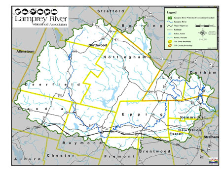
Start by having students locate their own homes and school on the map. These sites could be marked on the enclosed enlarged class map (or the USGS maps). If the maps are laminated or covered with contact paper, use a washable marker and reuse the maps. Have students compare their idea about the sequence of locations on the river with the map. Use the map to answer these questions (see Lesson 1.2 in the elementary portion of the curriculum for answers):
- Where does the Lamprey begin?
- Approximately how long is it? (Use string, then a ruler; the length of the river is 47.3 miles from the headwaters to Great Bay)
- If using topographic maps, how many feet does the river drop in elevation from source to mouth? (600 ft.)
- What are its major tributaries?
- What towns does it pass through?
- What lakes and ponds are part of the Lamprey watershed? (Have students been to any of them?)
- Where is the river's mouth?
- What can you tell from the map about human interventions with the river? (e.g., dams, man-made lakes)
- What separates one watershed from another? A topographic map can make the point that watersheds are separated by a height of land, or "divide," even if it's not very high.
Students can confirm their conclusions and answer other questions about physical attributes of the Lamprey while watching the film. For example: How large is the area the Lamprey drains? (214 square miles) How much water flows to the river? ("A trickle" to 7,570 cubic feet per second at flood stage; it is the largest river flowing into Great Bay). How did the river first begin (glacial melt water) and where does the water in the river come from now (rain)?
Extensions:
David Sobel's Mapmaking with Children has excellent suggestions for a wide variety of mapping activities, including making relief and topographic maps, all appropriate for high school students. Land Sat photographs and GPS data are good supplementary sources of information (USGS Website: http://mapping.usgs.gov/).
Lesson #3 in the elementary portion of the curriculum includes directions for groups of students to create town-by-town segments of a map of the Lamprey, to be assembled for a hall or class display. Older students can also gain greater familiarity with the river from this hands-on activity.