Lesson 4 a: CONDUCTING A STREAMWALK
Overview:
This lesson focuses on taking children to the Lamprey River and allowing them to examine the ecological health of a section or sections of the river. A streamwalk could be added to the other activities suggested in Lesson 4 or the whole class could conduct a streamwalk as a separate field trip. Included in the lesson are explanations of various factors that determine the river’s health. Students will learn how to conduct a streamwalk and understand the importance of monitoring the ecological health of a river.
Focus:
How healthy is the river habitat at this site? Is this a good place for plants and animals to live?
Learning Objectives:
Students will be able to
- enhance their understanding of the river and its health;
- learn what elements determine a river’s ecological health;
- conduct a streamwalk and use observations to complete the streamwalk checklist;
- draw conclusions about the river’s health.
Materials for each class:
__DVD: "Streamwalk"
__copies of questions about "Streamwalk" for the class or teams
__copies of the background information and/or access to the internet
__copies of the Lamprey River Streamwalk checklist for teams
__photographs of a section of the river which you won’t visit
__maps of the section of the river you’ll visit and the section you’ll study in your pre-field trip activity
__clipboards
__pencils and sharpeners
__measuring tapes
__water viewer made by each team (half gallon milk carton, plastic wrap, rubber band)
__camera
__binoculars
__rubber boots (optional)
__Global Positioning System instrument (optional)
__for the optional macroinvertebrate survey: pail, shallow white pan, tweezers and/or soft brush, and magnifying glass
__See Lesson 4 for other materials needed for a field trip to the river.
Procedure:
1. Watch "Streamwalk", a video produced by the Lamprey River Advisory Committee and the Lamprey River Watershed Association to learn about streamwalks. Contact the Advisory Committee to obtain a free copy of the DVD or go to www.lampreyriver.org and click on the videos tab on the left side of the home page. Use the video viewing activity which includes questions and guidelines for times to pause the video, so students can answer the questions.
2. Organize the class into working teams. Give each team a copy of the streamwalk checklist and ask members to examine the various parts of the checklist. Which words or phrases are unfamiliar to them? As the students share these words, record them on the board or in a word document that is displayed on a screen or whiteboard. (Terms they need to understand are: adequate, inadequate, landmark, latitude, longitude, land use, riparian buffer zone, channel width, water surface, vegetation, river bank erosion, murky or pea soup water, algae or slime on rocks, point bars, gravel, unstable, woody debris, different river bottom types, depth, riffle, particles, and barriers.) You can assign various words or phrases to teams of students, then allow them to use the background information in the lesson to help them figure out the meanings of the words. Teams can also look up the words and find images that illustrate them on the internet. When teams have gathered definitions and images or drawings, their information can be shared orally, then organized into a booklet of definitions and illustrations, made into a game like bingo, or arranged in a word document that students can access. Teams should store their streamwalk checklist.
3. Gather the teams with their copies of the streamwalk checklist. Display the checklist on a screen or whiteboard. Focusing on one section of the checklist at a time, examine each part and question the importance of each part. Why should the riparian buffer zone be twice as wide as the river’s channel? Why is it better if more than half the river’s width is shaded at mid-day? How is the river affected if the banks are eroding? Why is it better if the water is clear? What is the importance of there being very little algae growing on the rocks in the river? Why is it better if the point bars are small, stable, and vegetated? Why do we want to see a variety of in-stream habitats? Why is it better if the riffle areas have boulders, rocks, or gravel? How do barriers affect the river? Teams of students can search for answers to one or two of these questions and report back to the class. The answers can be found in the background information, but students could also look for the answers on the internet. Their information can be shared in a word document, then displayed on a screen or explained orally to the class.
4. Gather the teams with their copies of the streamwalk checklist. Display the checklist on a screen or whiteboard. Working as a whole group, look at the streamwalk checklist. Go to the first section and read what it is asking students to observe about the river. The information gathered in parts 2 and 3 can be used here and shared by corresponding teams. Ask teams of students to study photos and maps of a section of the river they are not going to visit, then complete the first section. Discuss their conclusions about the riparian buffer zone pictured in the photographs. Continue in this way until teams have completed as much of the checklist as they can. In the notes section, record the class’s conclusions about the health of the river at this site. Record any concerns they have. Did they notice any special features of this site? Areas of concern or special features would be photographed in a real streamwalk and noted. (Note: Before this activity, visit a site on the river that the students will not visit and take digital photos. Print or place in an accessible file.)
6. Optional: For the macroinvertebrate survey, you will need a pail, shallow white pan, tweezers and/or soft brush, and magnifying glass. Adults with tall boots can go into the water and select rocks, sticks, and/or leaves to examine. Macroinvertebrates are organisms without backbones that can be seen with the naked eye, like clams, mussels, snails, worms, crayfish, and larval insects. There are 3 methods for locating them:
- Rock-rubbing method: Remove several submerged rocks from the stream (each side, the middle, and in between) that are 4-6 inches in diameter. Search the rocks for organisms or place the rock in a shallow white pan, add stream water, and brush with a soft brush or hands. (Clumps of gravel or leaves could be caddisfly houses.)
- Stick-picking method: Collect several short, 1 inch diameter sticks from the stream and place in a pail filled with stream water. Choose soft, pulpy wood with lots of holes found in flowing water, not buried in the bottom. Select one of the sticks and hold it over a white pan that is half full of stream water. Pick off the loose bark to find organisms that might be hiding in the bark or holes. Break the sticks apart and look in the woody material. Use tweezers and/or a soft brush to remove any organisms and place them in the pan. Look for organisms in the pail of water, too.
- Leaf-pack sorting method: Remove several handfuls of submerged leaves from the stream and place them in a pail. Examine each leaf looking for insects. Use tweezers and/or a soft brush to remove organisms and place them in a shallow pan containing stream water. Examine the water in the pail, too.
Note any macroinvertebrates. Examine the organisms using a magnifying glass, and then photograph them. Note the type and number of each kind of organism then return them to the stream. Types of organisms you might find are worm-like (worms and leeches), crayfish, snail-like organisms (snails and clams), and insects. Different species tolerate different levels of pollution, and they provide clues about the stream’s health.
7. Select the site for the streamwalk and visit it before taking the students on the trip. (Teachers are urged to seek out safe, interesting points in their own towns and visit them to check for suitability and safety before taking their students there.) Time how long it takes to get from one location to another and remember that it generally takes about 5 minutes to load and unload buses with passengers. Be sure to have written accurate directions for the bus driver. See lesson 4 for other instructions for planning a field trip.
8. Review information about the streamwalk goals and instructions before the field trip. Be sure the students know what group they will be in and who their chaperone will be. Any inadequacies should be photographed and indicated in notes.
9. Upon arrival at a site, have everyone gather together to hear a short site description, a review of safety measures, and purpose of observations and experiments at that particular site. Then have them get into their groups before going to the location. Each group should have a copy of the streamwalk checklist, camera, pencils, clipboard, measuring tape, binoculars, GPS, and boots.
10. Chart 1 and Chart 2 can be used to compare the data collected by different teams of students. Have students join you at the board, screen, or other meeting place. Team members should sit together with clipboards, pencils, and copies of the streamwalk checklist they completed at the river. Distribute copies of Chart 1 to each team or student. Display the same recording sheet displayed on the screen, overhead, whiteboard, or poster. Ask teams to share how they filled out each section of the streamwalk checklist. Record their responses on Chart 1 and ask students to do the same. Discuss all the different ideas and opinions about whether the riparian buffer zone, shade, condition of the banks, etc. were adequate or not. Have students decide which response should be used for each section. Circle the response the class chose for Chart 2. Chart 2 can be used in a similar way to compare the data collected at different sites or at different times of the year. You might ask the following questions: Why might their findings be different? What did they learn about the river? Is the site they visited healthy? Why or why not? What might be done to improve the health of the river at this location?
11. It is important to follow the field trip with classroom activities that involve identifying various things students learned about the river. Use the streamwalk checklist, photos, or other notes taken on the trip to add information to the charts and watershed map created in previous lessons. Discuss relationships between plants and animals and the environment. Find ways to let the community know about the streamwalk and what the class learned about the river.
Video Viewing Activity
Begin the DVD.
Pause when the map of the Lamprey River and a photo of the McCallen Dam appear on the screen and Jennifer Rowden says, “…down to the confluence at McCallen Dam in Newmarket.” Have students record what a streamwalk is. (It’s an inventory of the river.)
Resume play.
Pause right after Jennifer Rowden says “…whether or not there may be erosion present” and the river flowing over rocks appears on the screen. Ask students to list four things they might look for on a streamwalk. Allow time for students to share all the possible answers: invasive species, stormwater outfall, culverts, trees and trash in the river, the condition of the sides, erosion.
Resume play.
Pause when Eric Fiegenbaum says, “I think we did 3 sections of the river…,” and Eric and Katie are sitting on rocks. Have students record three reasons the committee began the streamwalk project. (No one had completed an inventory of what was impacting the river, to promote the river, so members of the community would go out on the river, so people would experience the river’s beauty)
Resume play.
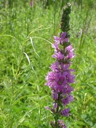
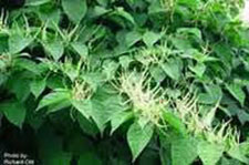
Pause when Eric says the tree across the river “is blocking canoe access, but gives some other structure for habitat” and the tree across the river appears on the screen. Ask students to name three things the volunteers found when they conducted the streamwalk. (It was encouraging: they found good buffers which included vegetation, trees, and forests; stormwater outfalls and culverts, runoff isn’t always filtered, invasive species like Japanese knotweed and purple loosestrife.)
Resume play for the completion of the video.
When the video ends, ask students to share and record why the streamwalk was valuable. (Volunteers learned what impacts the river and what needs to be corrected and they experienced the beauty of the river.)
Video Viewing Activity
What is a streamwalk? ______________________________________________________________
List four things to look for when conducting a streamwalk.
a)_______________________________________________________________________________
b)_______________________________________________________________________________
c)_______________________________________________________________________________
d)_______________________________________________________________________________
List three reasons the Lamprey River Advisory Committee began the streamwalk project.
a)__________________________________________________________________________
b)_______________________________________________________________________________
c)_______________________________________________________________________________List
List three things volunteers found when they conducted the Lamprey River streamwalk.
a)_______________________________________________________________________________
b)_______________________________________________________________________________
c)_______________________________________________________________________________
What was the value of conducting the streamwalk?
_________________________________________________________________________________
_________________________________________________________________________________
Background Information
What is a streamwalk?
A streamwalk is a method of identifying and assessing a stream’s habitat. It is mainly a visual observation of habitat, wildlife, and physical features. It does not require much training or equipment. It can be used to inventory an entire river to identify severe water quality problems and generate awareness of the river’s worth and special features. It encourages public awareness and involvement. The focus is on in-stream, stream bank and channel, and watershed characteristics. A macroinvertebrate survey is sometimes included. Teams ideally visit the same site three times a year: early spring, late summer, and fall or they visit several different sites. Teams complete a streamwalk checklist based on conditions in a stretch of stream both upstream and downstream of the place where they are standing. When working with students, the length of the stretch should be based on accessibility and safety.
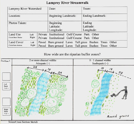
What are riparian buffers zones?
Riparian refers to river edges. Buffer zones are the vegetated areas on both sides of a river or stream. They include the soil, leaf litter, grasses, shrubs, vines, and trees that connect the water and land habitats. The riparian buffer zone should be at least twice as wide as the river.
Riparian buffer zones are important to the health of rivers, streams, lakes, and estuaries because they affect the flow of water, sediment, nutrients, pollution, and organisms between the land and river. They often have a greater variety of species than other zones and the growth is thicker. Plants that require a lot of water, like rushes, often grow only in riparian zones. This zone is home to many animals that move between land and water, such as insects, waterfowl, and otters. Riparian plants provide shade, food, and shelter for organisms in the river.
This zone acts as a natural sponge, soaking up water and slowly releasing it to the river. This helps prevent flooding and causes sediment to collect on shore rather than flow into the river. The plants also filter out pollutants, sediment, and nutrients, thereby reducing the amount of pollution and sediment flowing into the river. High levels of nutrients and pollution, along with low levels of oxygen, kill fish. Riparian plants also purify water for drinking.
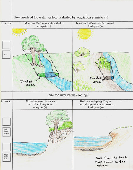
Why is shade important?
Shade is important in keeping water temperatures lower. Cooler temperatures, which are better for most water organisms, also slow the growth of algae. Riparian vegetation, both living and decaying, reduces erosion of river banks and affects the flow of water into the river. Roots hold the soil together and plants covering the ground reduce the impact of rain and water running down the bank.
What is river bank erosion?
River bank erosion is the gradual wearing away of sand, soil, plant material, and rock from the land at the edge of rivers. Forces that can cause this to happen are water, ice, wind, gravity, fire, and animal and human activities. Usually ground cover, such as rocks, trees, tall grass, bushes, leaves and other organic matter, protects river banks and prevents erosion. Plant roots hold the soil together and ground cover lessens the impact of the rain. But if something disturbs the ground cover, such as fire, road construction, clearing the land for houses or lawns, or burrowing animals, then the banks are more likely to erode. In our area, melting snow and heavy rains can lead to large amounts of water flowing over the banks. The force of the flowing water can carry sand, soil, rocks, organic matter, branches, trees, and trash into the river. As more water flows into the river, the increased depth, width, and the force of the river’s current can also wear away the banks. The material that has been washed into the river can collide with the river bank causing erosion.
The type of soil that the bank is made of is another factor in erosion. Sand will wash away more quickly than rocks or clay. Cold temperatures are a factor in erosion, too. Water seeps into pores and cracks in rocks during the day, then freezes at night. Water expands as it freezes, causing the rocks to crack even more. This process repeats itself many times and can gradually break rocks down into smaller and smaller pieces.
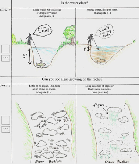
What is “water quality”?
Water quality is a measure of whether water is suitable for a certain use, such as drinking water, swimming, or habitat for fish. It is a measure of how clean the water is. To determine water quality, scientists examine it for things such as chemicals and bacteria. They also test its temperature, acidity, and dissolved oxygen level. Scientists then compare their findings to a set of guidelines established by the U.S. Environmental Protection Agency (USEPA). There are standards for drinking water and others for fish and birds.
Water quality changes naturally with the seasons, the weather, the types of soil and rock, and the amount of precipitation. As water from rain or snowmelt flows over and through the land, it can collect minerals, algae, bacteria, plant debris, sand, silt, and clay, and then carries them to streams, rivers, and lakes. Most common substances in water are minerals such as calcium, sodium, bicarbonate, plant nutrients such as nitrogen and phosphorus, and trace elements such as selenium, chromium, and arsenic. Most of these substances are not harmful in low concentrations, but some are. Although generally beneficial in low amounts, dissolved plant nutrients in high amounts can be harmful.
Human activities also affect water quality. One example is the nitrogen and phosphorus fertilizers that are put on lawns. These dissolve in water and then are carried to rivers. These nutrients also fertilize algae, causing them to grow and spread quickly. Too much algae leads to water cloudiness, smothering of beneficial aquatic plants, a high demand on dissolved oxygen in the water, and sometimes fish kills. Drugs, dry cleaning solvents, gasoline, and pesticides have been found in rivers. Bacteria and viruses can enter streams and rivers from leaking septic tanks, wastewater treatment discharge, and animal wastes.
What is sediment?
Sediment is made up of organic debris, clay, soil, sand, pebbles, and even rocks. Sediment is picked up by fast-moving water and washed into rivers during heavy rains or rapid snowmelts. As the water slows, these particles drop of of the water and settle on the bottom. Construction, road building, and bank erosion increase the amount of sediment in the water. Sediment can be re-suspended from the bottom when slow-moving water becomes fast-moving water.
Increased levels of sediment decrease the water quality and damage river habitats. The sediment often carries nutrients and toxic substances. When the sediment drops to the bottom, it covers the bottom and fills in pools, but some plants and animals need rocky bottoms, woody debris, or deep pools to survive. Sediment is also harmful to fish. Fish can swallow sediment, causing illness, reduced growth, and death. Some fish are unable to see their prey if too much sediment is in the water. Fish eggs suffocate and die when coated with sediment. Some eggs are sticky and need to attach to clean surfaces, but they cannot attach to things covered with sediment.
Invertebrates such mayfly larvae, leeches, and snails need clean, clear water to breathe and find food. They need clean rocks and woody debris to attach to and crevices between rock and branches at the bottom to hide from predators. Plants receive less sunlight if lots of sediment is in the water. Plants living on the river bottom can be smothered by sediment. Nitrates and phosphates in sediment can lead to too much algae and weed growth.
What are algae?
If you have ever seen green slime growing in a fish tank, then you have seen algae. Algae are tiny plants that grow in water and come in many shapes and sizes. They are mostly single celled plants. Although you need a microscope to see individuals, they can form colonies that connect and look like green slime.
Algae are both good and bad for a water habitat. Through a process called photosynthesis, they use the sun’s light, nutrients, and water to make their own food. The nutrients come from feces and dead animals and plants. Photosynthesis thus removes dissolved waste from the water. As a byproduct of photosynthesis, algae release oxygen gas, which humans and animals need to breathe. Algae are a food source for many animals, from microscopic animals to bigger animals such as mussels and certain insects and fish. Large colonies often provide hiding places for fish, insects, and other animals.
The bad thing about algae is they grow fast. If they have enough light, warmth, and nutrients, they can become too numerous and overwhelm an environment. Large amounts of algae often indicate that the water is polluted. As large amounts of algae die and decompose, the amount of dissolved oxygen available to fish and other organisms drops. This can lead to anoxia (no oxygen gas in the water or sediments) and fish kills.
In the heat of summer, several factors can combine to create a problem. 1. Gases, such as oxygen, do not dissolve well in warm water. 2. The bacteria that decompose dead plants and animals use dissolved oxygen gas as they do their work and reproduce. 3. Microscopic algae usually have short lives. When algae die, they sink and become food for bacteria. If there are many dead algae, the bacteria at the bottom will have a lot of food and they will reproduce. These bacteria will consume a lot of dissolved oxgen. 4. Cool, dense water at the bottom of deep, slow-moving water bodies often does not mix with warmer, less dense water at the surface. While water at the surface is exposed to oxygen from the air, the bottom water has less and less dissolved oxygen. 5. If the bottom water runs out of dissolved oxygen, the organisms that live at the bottom can be killed by suffocation or by poisoning that results from anaerobic (without oxygen) decomposition. This is what is commonly called a "fish kill". Fish kills are rare where algae are not abundant.
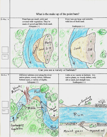
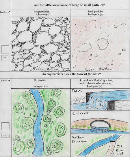
What is a point bar?
Point bars are places where sand and gravel are deposited on the inside bend in a river. They are found in rivers that meander or take many turns. They are sloping, crescent-shaped sand and gravel “beaches” that are close to water level. During floods, they are submerged and collect debris. A stable river does not have many point bars, but the ones it has are small and covered with plants and gravel with little or no fresh sand. A river that has large point bars at every turn and that are covered with fresh sand is an indication that erosion and/or flooding are problems.
Why is it good to have a varied in-stream habitat?
A habitat is a place where plants and animals live. The group of plants and animals that lives there is called a community. The plants and animals in a community use the air, soil, water, sunlight, climate, and space to survive and form an ecosystem. Plants are called producers because they use sun’s energy, nutrients, air and water to grow and produce roots, stems, leaves, etc.. Animals are called consumers because they eat the plants and/or other animals, but cannot produce their own food the way plants can.
A river or in-stream habitat that is diverse can support more plant and animal life. A variety of organisms can make use of a river that has different habitat features. Organisms vary in their ability to use or tolerate river depth, current, river bed characteristics, and vegetation. A river with habitat diversity has deep pools as well as shallow areas. The bottom ranges from fine particles such as sand to area covered by bare boulders. Its banks are covered by different types of plants - tall grasses, bushes, shrubs, and/or trees. There are places where trees and branches have fallen into the river creating the shade and protective cover some species prefer, while other areas are open.
A river that has little or no variety is not generally regarded as being as ecologically healthy compared to one with greater variety. A river whose bottom is covered with silt and sand, has no deep pools or riffles, and no plants is often recognized as less than healthy.
What is a riffle?
Riffles are shallow rapids in rivers or streams. The water in a riffle flows quickly over the gravel and rocky bottom. Because the water is not deep, lots of little waves and splashes are created at the surface which mix oxygen and nutrients into the water. Aquatic insects live in riffles eating algae, leaves, and other insects. Crayfish, mussels, and fish also live in riffles. Birds, such as herons, and mammals, such as beavers and muskrats, find food in riffles. Some species, like fish and frogs, breed in them.
Removal of vegetation and bank erosion can cause filling of riffles. Filling occurs when sand, soil, clay, and other particles enter the stream and cover the rocky bottom. When this happens, insects, crayfish, mussels, and fish are unable to find good hiding places or the food that collects between the rocks. Fish and frog eggs are smothered by the sediment. Less oxygen is mixed into the water, because there are not as many ripples and splashes.
What is a pool?
A pool is an area of deep water with slow, calm water. Silt and sand are usually found on the bottom of a pool, because when a river flows into a pool, the water moves slowly, allowing particles of silt and sand to drop to the bottom. Water temperatures in a pool are warm at the top and cold at the bottom.
What is a run?
Runs are sections of the river where the water moves quickly, but calmly. They have sand, gravel, or stone bottoms. The water moves too fast for silt to sink to the bottom, so the silt is washed downstream.
What can block or impede the flow of a river?
Structures that block the flow of rivers also stop the migration of fish. Such structures trap sediment, trees, branches, and trash that flow down the river. Dams, many of which were built to power mills or produce electricity, can impede the flow of rivers. Weirs, which are webs of nets and poles placed in a river to catch fish, can also hinder the migration of fish and trap trees and branches. Beaver dams block the flow of the river, creating large pools or ponds. Trees, branches, and other materials can collect in a part of the river, slowing water flow and fish migration. Manmade structures such as canals or roads built over culverts can block or divert the flow of the river.
How do dams affect rivers?
Because water is held behind a dam, the sections of the river below the dam often do not have enough water, but the parts of the river above the dam often have too much water for river species. Dams block the flow of nutrients, plants, fish, and other wildlife. Fish, such as salmon, need uninterrupted flows to help their young swim downriver and to help the adults swim upstream to spawn. Impoundments behind dams, which are calm and do not flow like rivers, can confuse fish in their migration.
Dams impact river temperatures. In shallow waters below the dam, the water is too warm for some species. Water in the pond behind the dam is cold at the bottom and warm at the top. If the dam releases water from the bottom of the pond, river temperatures become too cold. River species have adapted to and need surges of water in the spring for breeding and growth, but dams often release water at other times. During periods of heavy rainfall, flooding can occur behind the dam causing destruction to banks and habitats. When large amounts of water are released from the dam, banks are eroded, vegetation is uprooted, and habitats are changed. Impounded water often has lower levels of oxygen, so when water is released into the river, it does not have enough oxygen for some species. Silt collects behind the dam, burying fish spawning areas.
What other man-made structures affect the river?
Dams are probably the most obvious man-made structures in a river, but they are not the only ones. Culverts, pipes, and trash also change the river's natural physical and chemical traits. Culverts are structures that are designed to allow water to flow beneath a road or other obstacle. A well-designed culvert helps to protect both the road and the river from erosion. An under-sized, poorly designed culvert can have the opposite effect. Pipes that drain water from roads often increase erosion at the down-stream end. When this happens, the pipe becomes suspended above the normal water level. Fish migrating upstream will not be able to jump from the water into the pipe. Culverts and pipes are often places where run-off from roads and parking lots enters the stream. This run-off contains oil, anti-freeze, and other wastes associated with pavement. In addition, run-off from a hot road will be warm, and most fish do not well in warm water. Trash, whether large or small, does not belong in a river. It adds pollutants, diminishes habitat for wildlife, and can trap or choke animals.
What are some other easily identified issues?
Plants along the river help prevent erosion, provide habitat, and, often, shade. Not all plants are equal in the benefits they provide, however. Many people believe a lawn is good vegetation. A lawn is usually better than bare soil, but lawn is not good vegetation along a river. It provides no habitat or shade, it is not particularly good at holding soil or river banks, and too often it is treated with fertilizer, pesticides, and/or herbicides. These chemicals rarely stay in the lawn and instead run into the river. Fertilizer in water promotes the growth of algae, and pesticides often kill helpful aquatic insects.