Field Trip Directions:
1. Headwaters, Betty Meadows, Northwood Meadows State Park
https://www.nhstateparks.org/visit/state-parks/northwood-meadows-state-park
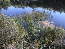
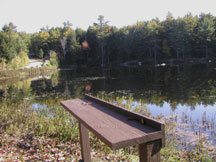
As you approach the lake, there is a swamp on the right of the road. That is a good place to collect water samples. It is shallow and on warm days you may see things swimming in it. On the left is the lake. We’ve often seen turtles sunbathing on logs as we approached the water. Mast Way School classes spent as much as 2 hours collecting data at the headwaters.
2a. Mary E. Folsom Blair Community Park, Epping
Note: Originally John Folsom Conservation Area was the recommended stop in Epping, but at this site many large trees have fallen across the trails making for a difficult trek to reach the river. Also, the vegetation at the edge of the river is thick, making water tests difficult.
Return to Route 4 heading east which is a right turn.
Go 3 miles and turn right on NH--Route 43 south.
Turn left onto Routes 107 and 43 at the stop sign.
Soon after this turn, the bus will pass Freese's Pond and Dam and will basically follow the route of the Lamprey River.
Stay on Route 107.
Bear left where Old Route 101 and Route 27 join Route 107.
In Raymond, take Route 27 to West Epping.
Go 1.6 miles and turn left onto Folsom Mill Road.
The park is a short distance down this road. Follow it into the park where there is plenty of parking.
It takes about 40 minutes to drive from Northwood Meadows to Mary Blair Park.
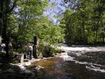
There is a kiosk with information about Mary Blair and the park. There often is a portable toilet near the kiosk. Beyond the kiosk and toilet is an area where you can look out over the river and see remnants of the dam that was removed in 2011, a bridge, and parts of mill foundations. The lower part of this opening could be used for water tests, but it is rocky. If you walk over some of the short trails, you’ll see more rock formations. A good spot to conduct water studies is the wide open area where the Epping Conservation Commission’s annual Lamprey River Canoe Race begins. It slopes gradually and is not rocky. Beyond this canoe launching area, the banks of the river become high and steep, so children should not conduct their tests further down the river. The park road continues on with the river on one side with steep banks and a baseball field on the other side. See the link below for a map of the various rock structures.
This is a link to the Epping Conservation Commission page pf properties.
This link will take you to information about Mary Blair Park.
2b. Epping Town Hall: Another possible site in Epping is a park behind the Epping Town Hall. Access it from the town hall parking lot off Route 27. From Mary Blair Park, continue on Route 27 toward Epping village. After crossing Main Street, go past a pizza restaurant and dry cleaner. Immediately turn left into the parking lot. It’s a large lot with room for a bus to park. Walk to the grassy area behind the town hall, a tall brick building with a steeple. Cross the grassy area and see the Lamprey River. To the right of the grassy area is a trail that leads down to the river. As you walk the trials, look for signs of rock and brick structures. There’s also a large iron hook attached to a large boulder in the middle of the river. Further down the trail is a flat area where you can conduct water tests. There are also lots of different ferns and wild plants growing along the river.
3. Wadleigh Falls in Lee
Directions:
Return to Route 27, turning right toward Epping village.
Proceed to Route 125.
Turn left onto Route 125 toward Lee.
Take a right onto Highway 152. (There’s a stop light at this intersection.)
Continue on 152 until you cross the bridge over the Lamprey. Park at the small turn-off on Tuttle Road.
This site is best viewed in passing. This is not an appropriate site when the river is high in the spring. Access is available only with permission of local private landowners. With small, well-supervised groups, there are some interesting historic features: supports for an old flue, parts of the dam, and the depressions in the bank where vats holding chemicals to prepare leather were placed. Visitors might also find old leather scraps, remains of an old wagon, bits of crockery, fishing line, beverage cans, and other evidence that humans have used the area from the past to the present time.
4. Heron Point Sanctuary (near the mouth of the river), Newmarket
Continue to Newmarket.
In Newmarket, turn left onto Route 108 and continue over the bridge.
Immediately after crossing the bridge, turn right onto Bay Road.
Drive about 1/2 mile until you come to a mobile home park.
Turn right and drive into the mobile home park.
Drive a short distance to the Heron Point Sanctuary.
Turn right onto the dirt road and continue to the parking lot.
This drive takes about 30 minutes.
Gather and study the sign with a map of the sanctuary.
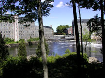
Then, keeping the students on the upper outlook platform, look across the river at the Newmarket mills.